Sunrise over the Garden City Lands welcomes a bright new day for Richmond.
| Home | Answers | Future | Action | About Us |
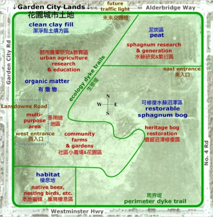
The 2011 PARC concept shown below is the best current concept for the future of the Garden City Lands. It is founded on a concept that Coun. Harold Steves has been putting forward for several years.
This discussion is illustrated by the PARC graphic. Park stands for
Parkland for Agriculture, Recreation & Conservation.
When we look and listen, the Garden City Lands tell us what¡¦s good for
them.
In the graphic, the underlying image is a satellite view in rainy
season. Wetter areas look darker. Notice, for example, the light ¡§clean
clay fill¡¨ in the northwest corner and the darker¡Xand wetter¡Xlower-lying
land south of it.
More subtly, several of the labeled areas convey the close-range view of
Michael Wolfe, who knows and loves the ecology of the lands. He spent
time with them this spring to map where he found native species,
streams, and more.
A few streams caught the satellite¡¦s eye, but Michael located a hidden
one with banks of abundant cloudberries and sphagnum. It¡¦s east of the
green ¡§ecology dyke trails¡¨ label and parallel to it, easy to miss but
well worth conserving.
Aspects like that are the lands¡¦ way of showing us the ¡§restorable
sphagnum bog,¡¨ which can be saved with dyking that holds in the acidic
bog water and lets precipitation raise the water table. Michael was
recording Nature¡¦s wishes when he drew a slanting and winding western
border, which could be the future route of a dike trail.
In the northeast, Michael found none of the living sphagnum moss that
enables a sphagnum bog. Still, it remains a field of ancient peat. With
the right planting method and water levels, that¡¦s an ideal base for
regenerating sphagnum. The city would witness the rebirth of a bog in
its midst.
Although the bog ecosystem of the Garden City Lands is in critical
shape, the published resources of the Canadian Peat Moss Association
prove there are Canadian experts who could help. Also, the 2008
Lulu Island Bog book describes
efforts to save bog remnants east of the Garden City Lands, and we can
learn from the scant success. Leading-edge care is essential. Deep
commitment will enable full recovery.
Agriculture expert Kent Mullinix says the higher land in the northwest
is suited to orchard trees and farm animals, which would rather not
stand in water. South of that, the soil is more organic. With drainage,
it can become productive for growing.
The areas for agricultural education and community farms and gardens
could be crisscrossed by a trail system designed to feed visitors¡¦
interest while prompting respect for what others grow.
The Garden City Lands have cousins, the Terra Nova Rural Park and
Natural Area far to the west, role models to imitate in adapted ways.
Farming groups outgrowing the Terra Nova Sharing Farm in the rural park
would make good early adopters of community farms on the lands, and Food
Bank clients might be able to help grow their food there.
In time, the 120,000 people who will be jammed into the city centre may
require 25 acres for community gardeners on the lands. They¡¦d grow
culturally good food, chat with their garden neighbors and passers-by,
and savor the settings of mountains and woods.
Around the west entrance, the most disturbed part of the lands is
labeled ¡§multi-purpose area.¡¨ Clean clay fill, which would be brought in
for trail-bearing dykes, could also extend the existing firm ground.
That would suit buildings like a multi-purpose community barn and
farmgate market, along with a little parking.
In the southwest corner, nesting birds and native bees reminded Michael
that the water conditions and vegetation there are just right for them.
Bee expert Brian Campbell tells us that native bees are best for
pollinating native plants. Some species don¡¦t fly far from their nests,
but they can be helped to find homes where their work is needed. For
natural harmony, the ¡§habitat¡¨ corner calls for distinct handling.
Those who listen to the Garden City Lands love to share the joy. They
envision peaceful gathering places, tai chi beside reservoir lakes,
theme playgrounds, lookouts, and lots of interpretive signs on
all-weather trails for walking, cycling, and access.
By B.C. law this ALR land is agricultural, by nature it cries out for
conservation, and as green wellness space in the city centre it¡¦s vital
for recreation. So the Garden City Lands can be a great ¡§PARC,¡¨ which is
more than a nod to bilingualism en
francais. As PARC, they¡¦re Parkland for Agriculture, Recreation, and
Conservation.
The prospects are exciting. When we listen to the lands, enthusiasm is
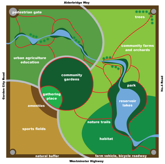
natural. Early visionsMany alternatives to high-density development have previously been proposed. At the 2008 Garden City Lands open houses, Garden City Lands Coalition members were available at all times to listen to the visitors' ideas. The vast majority of visitors wanted to keep the Lands for purposes that can be permissible within the Agricultural Land Reserve (ALR). Urban agricultural education was very popular, and a surprising number of people would be content to leave the lands the way they are. What the supportive visitors had in common was the desire to keep open green space. Many of the open house visitors were concerned about retaining the food-growing capability for community uses. There was a general willingness to compromise on particular uses provided that the lands are kept in the ALR and not built up. The following illustration expresses the Richmond citizens' vision. It's all possible within the ALR. The citizens¡¦ vision map for the Garden City Lands is conceptual, and many of the features would ultimately be located in different places. For example, the main reservoir lake would be placed wherever the City engineers and agrologists choose, perhaps in the wide strip of non-bog fill in the northwest part along Alderbridge Way. (Most likely, the southeast area where the artist put it would be problematic because it might actually drain the bog.) Similarly, while some of the trails are in logical places, others are just where the artist happened to put them.
Note: With regard to natural-turf playing fields, the Agricultural Land Commission used to give permission for a lot of sports uses and still allows them occasionally, but a study of decisions related to sports fields in recent years shows that approval of that use would be extremely unlikely even if wetlands were not obviously unsuited. However, having the Garden City Lands as agricultural park with habitat and trails would reduce the need for that kind of park elsewhere. In that context, it can be anticipated that "Save Garden City" advocates, who certainly include many supporters of improved sports-field availability, will support improvements like new all-weather sports fields, as needed, in more appropriate parts of Richmond even more strongly. Other proposals for the future of the Garden City Lands include:
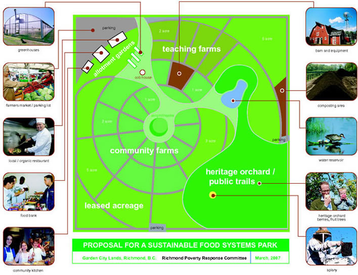
One alternative is the Sustainable Food Systems Park Keeping the Garden City Lands in the ALR and developing a Sustainable Food Systems Park would put the city of Richmond on the world map as a forward-thinking community that is well positioned in terms of food security. Besides attracting tourists, the park would afford opportunities for:
All farm equipment and machinery would be kept on-site, so there would be no interference with local traffic. For more insight into the future of the Lands, visit the Garden City Lands blog. Reminder: The Garden City Lands Coalition is a community of people who want the Garden City lands, Richmond, BC, to remain green in the Agricultural Land Reserve (ALR) for agricultural, ecological and park uses for community benefit.
|
Copyright © 2011 Garden City Conservation Society, Richmond, B.C., Canada | Website designed by Zboya Design


